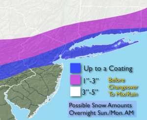
Synopsis:
Scattered areas of light snow is expected this afternoon and evening as a system develops to our West. This initial area of snow could leave a coating in spots by the evening hours. Snow Lovers, unless you live well North and West of the City this will be a dud. The primary low over the Ohio valley will be remain the dominate feature. This will result in a warmer atmosphere for our area. High pressure in Quebec will supply the cold air, but the high will lose its influence over the coastal plain. The snow will change to rain at the coast and farther to the South during later Sunday night and Monday morning. A minor accumulation is possible here before the changeover. Inland the cold air will be stubborn to erode. This will result in higher snow amounts with a change to freezing rain and or rain for some areas. The possible snow amounts are above. This will not be a significant wintry event, but it will remain active with several shots of Arctic air heading into Christmas.
This Afternoon & Evening:
Areas of light snow, especially North of a Trenton, NYC line. A dusting to a coating is possible by evening. Temperatures will be in the mid to upper 30s. Northwest wind will become South at 5mph.
Tonight:
Snow will go over to a mix of freezing rain and sleet inland. Along the coast the snow will go over to rain. There maybe a lull in the precipitation during the evening with steadier precipitation moving in toward midnight. Rising temperatures overnight-rising through the 30s and to near 40º at the coast by morning. Inland temperatures will rise through the 20s to near freezing by sunrise. South wind at 5-10mph.
Monday:
Mix, freezing rain or rain inland (depending on your location) in the morning. Rain at the coast. The precipitation will taper within a few hours of mid-day. Late day sun is possible. Highs in the 40s to around 50º at the coast.
Tuesday:
Partly sunny. Highs in the mid 40s.
Wednesday:
Partly sunny. Highs in the mid 40s.
Thursday:
The Arctic Express arrives.. Partly sunny, windy and very cold. Highs in the upper 20s to around 30º.
Stay Tuned.
Keep it here for a no nonsense, no hype forecast.