Synopsis:
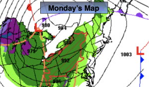
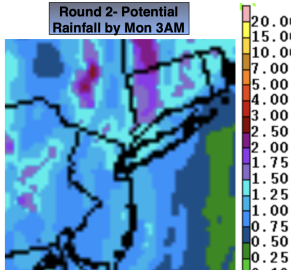
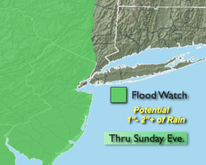
An intensifying storm over Eastern Virginia will move North and just inland of the coast to NYC by Midnight. Rain will continue through this time frame, locally heavy at times. The region will receive between a 1/2″ to 2″ of rainfall by 3am Monday. A Flood Watch is in effect for all of New Jersey, Eastern PA and the Lower Hudson Valley, West of the Hudson River. Additional heavy rainfall will cause areas of flooding into tonight. If you encounter a flooded roadway- turn around, don’t drown. The rain will taper off from Southwest to Northeast within a few hours of midnight. Winds will be busy and gust to over 30mph with the passage of the low.
We’ll get to dry out on Monday behind the deepening storm to our North. The sun will finally return for a time but clouds will win the battle during the day. An isolated shower can’t be ruled out later in the day and evening.
An upper level low will spin over the Northeast and remain basically stationary. This will result in a basically what you see is what you get forecast. More clouds than sun is expected with spotty showers and unseasonably cool temperatures. Welcome to May.
Stay tuned.
Keep it here for a no nonsense, no hype forecast.
Tonight:
On and off rain through midnight. Local downpours. Breezy. Lows in the lower 50s in the City, the upper 40s inland. East to Northeast winds becoming West at 15-25mph with gusts to 30mph.
Monday:
Early sun, otherwise mostly cloudy. Isolated shower possible late. Highs in the lower 60s. West to Southwest winds at 15-25mph.
Tuesday:
More clouds than sun. Spotty showers. Cooler. Highs in the mid to upper 50s.
Wednesday:
More clouds than sun. Spotty showers. Chilly. Highs in the mid 50s.
Thursday:
More clouds than sun. Spotty showers. Highs in the upper 50s.
Friday:
More clouds than sun. Spotty showers. Highs in the upper 50s.