Synopsis:
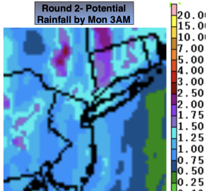
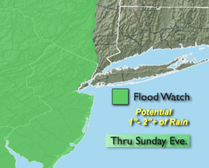
A second storm- round 2, will develop on the heels of the first storm over the Southeast and ride up the Piedmont this afternoon and night. Rain will move in by mid to late morning and continue on and off into tonight. The rain will be heavy at times. The region will receive between a 1/2″ to 2″ of rainfall by 3am Monday. A Flood Watch is in effect for all of New Jersey, Eastern PA and the Lower Hudson Valley, West of the Hudson River. Additional heavy rainfall will cause areas of flooding into tonight. If you encounter a flooded roadway- turn around, don’t drown.
Today won’t be as cool as a milder fetch works in from the South and East later this afternoon. Winds will once again pick up during the day Sunday as the storm approaches from the South.
We’ll get to dry out on Monday behind the deepening storm to our North. The sun will finally return.
An upper level low will move over the region on Tuesday through Thursday with scattered showers and unseasonably cool temperatures. It’ll be a broken record forecast for sure.
Stay tuned.
Keep it here for a no nonsense, no hype forecast.
Sunday:
On and off rain. Breezy. Highs in the lower 60s. East winds increasing 15-25mph with gusts to 30mph.
Tonight:
On and off rain through midnight. Breezy. Lows in the lower 50s in the City, the upper 40s inland. Winds becoming West at 15-25mph with gusts to 30mph.
Monday:
Partly sunny. Highs in the mid 60s.
Tuesday:
More clouds than sun. Spotty showers. Cooler. Highs in the upper 50s.
Wednesday:
More clouds than sun. Spotty showers. Chilly. Highs in the upper 50s.
Thursday:
More clouds than sun. Spotty showers. Highs around 60º.