Synopsis:
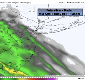
Clouds will win the battle on Friday ahead of low pressure moving up from the South. The morning will be dry. Showers will work in from West to East during the mid to late afternoon over NJ and into the City during the evening. Readings will be well below the average high of the mid 60s. Winds will become quite gusty later today.
Rain is likely tonight into the majority of Saturday as low pressure grazes the NJ coast. The rain will become lighter and more intermittent during the afternoon on Saturday. It’ll be chilly with a wind off the cold Atlantic.
A brief break in the rain will occur in the rain Saturday night into Sunday morning. But a second storm will develop on the heels of the first storm over the Southeast and ride up the Piedmont later Sunday afternoon and night. Any sunshine will give way to thickening clouds on Sunday. Rain will move in during the afternoon and become steadier by mid to later afternoon. Rain is likely Sunday night as the storm deepens considerably over our area.
We’ll get to dry out on Monday behind the deepening storm to our North. The sun will finally return.
An upper level low will move over the region on Tuesday with scattered showers and unseasonably cool temperatures.
Stay tuned.
Keep it here for a no nonsense, no hype forecast.
Friday:
Thickening clouds. Showers move in from West to East during the afternoon. Highs in the upper 50s. East to Southeast winds at 10-15mph with gusts to 20mph.
Tonight:
Rainy and windy. Rain could be locally heavy at times. Lows in the 40s throughout. East to Northeast winds at 15-25mph with gusts to 30mph.
Saturday:
Rain. Windy and chilly. Highs in the lower to mid 50s.
Sunday:
Limited morning sun otherwise thickening clouds with rain moving in during the afternoon. Highs in the lower 60s.
Monday:
Partly sunny. Highs in the mid 60s.
Tuesday:
More clouds than sun. Spotty showers. Cooler. Highs in the upper 50s.