Synopsis:.
High pressure will dominate through Friday. A mix of sun and clouds is expected through the end of the week. There will be a hiccup in our weather later this afternoon and tonight with spotty showers working through as upper level energy moves across the region. Temperatures will be below the average high of 65º by about five degrees the entire week. Yes, a chilly feel.
By Friday night and Saturday the atmosphere will begin to wake up. The latest computer guidance suggests a Southern low will make a run for our area. The chance of rain is in the forecast for Friday night and Saturday. Sunday should be the better half of the weekend as we’re in between low pressure systems. A mix of sun and clouds is expected with mild readings.
Stay tuned.
Keep it here for a no nonsense, no hype forecast.
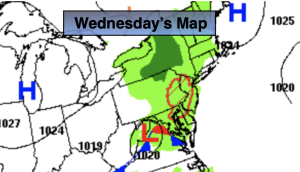
Wednesday:
Becoming mostly cloudy. Scattered afternoon showers. Cool. Highs in the mid to upper 50s. Northeast to Southeast winds at 5-10mph.
Tonight:
Mostly cloudy with spotty showers. Lows in the mid 40s in the City, the upper 30s and lower 40s inland. Southeast winds at 5mph.
Thursday:
Spotty morning shower east otherwise, clouds to sun. Cool. Highs in the lower 60s.
Friday:
Increasing clouds. Highs in the lower 60s.
Saturday:
Chance of rain. Highs in the upper 50s.
Sunday:
Partly sunny. Highs around 70º.