Synopsis:.
Temperatures will rebound nicely through Tuesday as high pressure moderates and the sun dominates.
A warm front will approach on Wednesday and stall just to our South. This has resulted in a hiccup for midweek forecast with clouds, cooler readings and the threat of showers.
Readings will feel like early June on Thursday. High pressures will move off the coast and a Southwest flow will take hold. A mix of sun and clouds is expected with a chance of afternoon scattered showers later Thursday.
More seasonable conditions are expected on Friday along with abundant sunshine.
Stay tuned.
Keep it here for a no nonsense, no hype forecast.
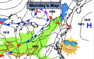
Monday:
Sunny. Milder. Highs in the lower 60s. Winds increasing to 15-25mph during the afternoon.
Tonight:
Partly cloudy. Much milder than recent nights. Lows in the upper 40s in the City, the lower 40s inland. South winds diminishing to 5mph or less.
Tuesday:
Partly sunny. Mild. Highs in the mid 60s.
Wednesday:
Cloudy. Cooler. Chance of showers. Highs in the mid to upper 50s.
Thursday:
Sun to clouds. Warm. Chance of afternoon scattered showers. Highs in the mid to upper 70s.
Friday:
Mostly sunny. More seasonable. Highs in the mid to upper 50s.