Synopsis:
Sunday will feature a much brighter sky with milder readings than Saturday as high pressure works in.
All is quiet as we start next week with mainly sunny skies on Monday. Tuesday will feature weak low pressure moving across the Northeast. Shattered showers are possible in the morning. Monday will be mild. Tuesday’s readings will be near the average high of the mid 40s.
Wednesday and Thursday will feature a brisk North wind created by the difference in strong weather systems. Intense low pressure be draped over the North Atlantic with strong high pressure centered over central Canada. A mix of sun and clouds is expected with highs around seasonable levels.
Stay tuned.
Keep it here for a no hype, no nonsense forecast.
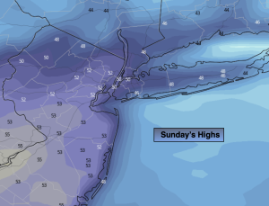
Sunday:
Mostly sunny. Milder. Highs in the upper 40s to lower 50s Northwest winds at 5-15mph with a few higher gusts.
Tonight:
Mostly clear. Lows in the mid 30s along the urban corridor, the upper 20s inland. Northwest winds at 10-15mph.
Monday:
Mostly sunny. Mild. Highs in the lower 50s.
Tuesday:
Mostly cloudy. Scattered showers. Highs in the mid 40s.
Wednesday:
Partly sunny. Breezy and seasonable. Highs in the mid to upper 40s.
Thursday:
Mostly sunny. Breezy and seasonable. Highs in the mid to upper 40s.