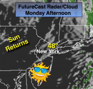
Synopsis:
The weak disturbance that gave interior sections a coating of snow and rain elsewhere is moving rapidly off the coast. Any precipitation will end this morning. A ridge of high pressure will moving into the area will result in skies becoming mostly sunny later this morning and afternoon. It’ll turn out to be a decent Monday. Highs will be in the upper 40s. Another low pressure system will affect the area later Tuesday into Wednesday. This time around it looks like mainly a rain event as a warm Southerly flow aloft will prevail. Any sun will give way to thickening clouds Tuesday with light rain developing toward sunset. A significant season changing front will move into the area by Friday. Plummeting temperatures and high winds are anticipated into next weekend. Stay tuned.
Today:
Morning light rain and snow will end, otherwise becoming mostly sunny. Highs in the mid to upper 40s. South to Northwest wind at 10-15mph.
Tonight:
Mostly clear. Lows in the upper 30s in the City, the mid 20s inland. Northwest wind at 5-10mph.
Tuesday:
Morning sun will give way to clouds. A chance of rain possibly mixed with snow and sleet for a time well inland by late afternoon. Highs in the mid 40s.
Wednesday:
Mostly cloudy with light rain or drizzle possible. Highs in the mid 40s.
Thursday:
Mostly cloudy with a few showers possible. Highs in the upper 40s.
Friday:
Partly cloudy, windy and much colder. Highs in the 30s.
Stay Tuned.
Keep it here for a no nonsense, no hype forecast.