Synopsis:
Clouds will dominate today, the exception being Southern areas where the sun may shine at times. Spot showers can’t be ruled out as the system pulls into the this afternoon.
Sunday will feature a much brighter sky with readings a few degrees above the average of the lower to m id 40s.
All is quiet as we start next week with mainly sunny skies on Monday. Tuesday will feature weak low pressure moving across the Northeast. Shattered showers are possible. Both days will feature readings above the average high of the mid 40s. More seasonable readings are expected for Wednesday as a cool flow takes hold.
Stay tuned.
Keep it here for a no hype, no nonsense forecast.
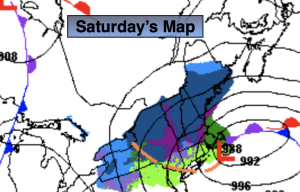
Saturday:
Mostly cloudy. Scattered shower possible. Some sun to the South. Highs in the mid to upper 40s. Northwest winds at 15-25mph.
Tonight:
Partly to Mostly cloudy. Lows in the 30s throughout. Northwest winds diminishing to 5mph.
Sunday:
Mostly sunny. Milder. Highs in the upper 40s to around 50º.
Monday:
Mostly sunny. Mild. Highs around 50º.
Tuesday:
Mostly cloudy. Scattered showers. Mild. Highs in the lower 50s.
Wednesday:
Partly sunny. Seasonable. Highs in the mid to upper 40s.