Synopsis:
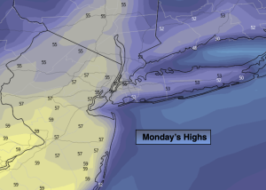
Presidents’ Day temperatures will reach early Spring readings once again as a weakening cool front approaches. The day will start with plenty of clouds but the sun will make a visit during the afternoon. Tuesday will be no different with above average readings. Scattered showers are in the forecast for the second half of the day as a disturbance to the North skirts our region.
A storm will develop over the mid-section of the country for the second half of the week. The track of the low will (like all its predecessors) move well to our North and West. This is a no snow solution. A warm front associated with the storm will move our way later Wednesday with afternoon showers a bit of sleet may mix in, especially North and West. Morning showers on Thursday should give way to the possibility of some sun, especially South and West. It now looks like the warm front will not swing through the region, meaning the 60s won’t pay a visit.
A gusty Northwest wind will develop around a deepening storm South of Nova Scotia on Friday. A mix of sun and clouds are expected with readings a few degrees above average.
Stay tuned.
Keep it here for a no hype, no nonsense forecast.
Presidents’ Day:
Clouds with some sun, mild. High in the mid 50s. West winds at 8-12mph.
Tonight:
Mostly cloudy. Scattered showers. Lows in the lower 40s in the City, the upper 20s and 30s inland. Northwest to Northeast winds at 5-10mph.
Tuesday:
Mainly cloudy with scattered showers in the afternoon. High in the upper 40s.
Wednesday:
Any morning sun giving way to thickening clouds and afternoon showers. Some sleet possible for the Northern half of the tri-state area. Cooler. High in the lower 40s, 30s inland.
Thursday:
Morning showers, otherwise mostly cloudy. High in the 40s.
Friday:
Partly sunny. Breezy. High in the 40s.