Synopsis:
Saturday we’ll finally contend with near seasonable readings for daytime highs as cooler high pressure takes hold. The chill won’t last as the high move offshore and the mild return flow greet us for the second half of the weekend. Both days will feature mainly sunny skies.
On Presidents’ Day temperatures will once again reach early Spring readings ahead of an approaching cold front under as mix of sun and clouds. Tuesday will be no different with above average readings continuing with a chance of afternoon showers as a weak disturbance to the North skirts our region.
It’ll be a midweek delight with mostly sunny and mild conditions Wednesday as a ridge of high pressure works into the region.
Stay tuned.
Keep it here for a no hype, no nonsense forecast.
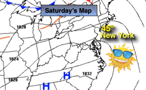
Saturday:
Sunny. More seasonable. Highs in the lower to mid 40s. Northwest to West winds at 8-12mph.
Tonight:
Clear. Lows in the mid 30s in the City, the upper teens and 20s inland. Southwest winds at 5mph.
Sunday:
Partly sunny, mild. High around 50º.
Presidents’ Day:
Partly sunny, mild. High in the mid 50s.
Tuesday:
More clouds than sun. Chance of afternoon showers. High in the upper 40s to lower 50s.
Wednesday:
Mostly sunny Mild. High in the lower 50s.