Synopsis:
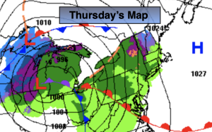
Low pressure will move into the Great Lakes today. A warm front (map above) will swing North through our area by late afternoon. Spotty showers are possible just about any time, but the majority of the day will be dry. It’ll be mild with a Southerly flow.
Friday will feature partly sunny skies and guess what? Mild temperatures as modified cold air will be well to our North and West.
The front will push offshore Friday night. High pressure will move in for Saturday will cooler readings. Highs still will be a few degrees above the average high of around 40º.
On Sunday low pressure will develop in the Carolina’s. The latest computer guidance continues for a low to moderate potential of some rain and gusty winds mainly closer to the coast later in the day and at night. Both weekend days will be near or above the average high of around 40º.
Whatever happens with the storms specific track, the precipitation threat will be out of the region by Monday. There maybe leftover coastal rain ending early in the morning. Clouds will give way to mainly sunny skies by afternoon and yep, mild readings will stick around.
Stay tuned.
Keep it here for a no hype, no nonsense forecast.
Thursday:
Mostly cloudy with spotty showers. Mild. Highs in the lower 50s. Southeast winds at 5-10mph.
Tonight:
A spot evening shower, otherwise becoming partly cloudy late. Very mild. Lows in the 40s throughout. The lows will higher than the average highs for the date! Southwest winds at 5-10mph.
Friday:
Sun and clouds. Mild. Highs in the mid to upper 50s.
Saturday:
Mostly sunny Cooler. Highs in the mid 40s.
Sunday:
Sun giving way to increasing and thickening clouds. Potential of some rain, especially by the coast later in the day. Highs in the lower 40s.
Monday:
Any early morning clouds and rain at the coast, otherwise becoming mostly sunny. Highs in the upper 40s.