Synopsis:
High pressure over the central part of the country combined with strong low pressure in Eastern Canada will keep the winds busy the next several days. It will be dry and more seasonal for this time of the year with a mix of sun and clouds. Looking down the pike my eyes are on a potential low pressure system that may affect the area later Tuesday. The models have been it a state of mayhem with the solution. Lets see how the elements come together over the next couple of days. Cold high pressure wants to hang on over the Northeast but the warm Southerly flow aloft will most likely prevail. The other issue, the latest computer guidance suggests the the bulk of the precipitation slides to the South and off the coast. The chances of any snow are minimal at this time. With a mix to rain quite possible inland. Stay tuned.
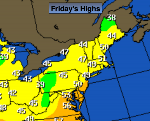
Today:
Partly sunny and breezy. Highs near 50º. West wind at 15-25mph.
Tonight:
Mostly clear and colder. Lows in the upper 30s in the City, near freezing inland. West wind at 10-20mph.
Saturday:
Partly sunny, breezy and seasonal. Highs in the mid to upper 40s.
Sunday:
Sunny, cool. Highs in the mid 40s.
Monday:
Mostly sunny. Highs in the mid to upper 40s.
Tuesday:
Morning sun will give way to clouds. A chance of rain possibly mixed with snow and sleet for a time inland later in the day. Highs in the mid 40s.
Stay Tuned.
Keep it here for a no nonsense, no hype forecast.