Synopsis
We’ll finally come out of the ice box today. The frigid pool of air has lost its grip over the region. We have not been above freezing since last Friday afternoon. High pressure will continue to build along the East coast for the rest of the week. A developing Southwest flow will result in a warming trend. Temperatures will get above average by tomorrow (average temps are around 40º for highs) and flirt with 50º for the rest of the five day period. Enjoy the break from the cold while it lasts!
The next chance of showers will come Saturday, New Year’s Eve. Low pressure will move out of the Southern Appalachians. It’s a mild storm track, equating to no snow.
Stay tuned.
Keep it here for a no hype, no nonsense forecast.
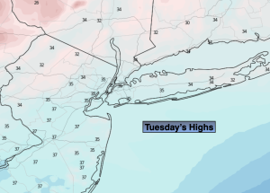
Tuesday:
Mostly sunny. Highs in the mid 30s. West winds at 5-10mph.
Tonight:
Mostly clear. Lows around freezing along the urban corridor to the teens and 20s inland. West to Southwest winds at 5mph.
Wednesday:
Sunny. Milder. Highs in the mid 40s.
Thursday:
Sunny. Mild. Highs in the upper 40s to around 50º.
Friday:
Mostly sunny. Mild. Highs around 50º.
New Year’s Eve:
Mostly cloudy. Mild. Chance of late day showers. Highs around 50º.