Synopsis:
Happy Hanukkah!
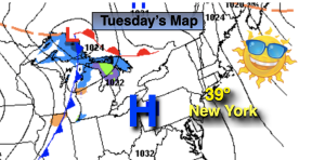
Tranquil conditions are expected through tomorrow as high pressure dominates. The sun will shine and readings will be below average by several degrees. Winter arrives on Wednesday at 4:48PM.
The well advertised storm for late week in the Eastern one half of the country will develop on Thursday over the Southern Plains. The track will be well West of our region and in to the Great Lakes by late Friday. This is a warm solution and will be a rain event. At the onset, the precipitation on Thursday afternoon may start as mix North and West but it will be short-lived as the mix will quickly change over to rain.
This will be a monster of a storm. Blizzard conditions and very strong winds are expected over the Great Lakes. Again, we are on the warm side. Rain may become heavy at times Thursday night into Friday morning. Winds will increase and become quite strong. It’ll be balmy Friday with most readings soaring into the 50s. Friday will not be a complete washout. In fact after the morning rain they maybe a break until later in the afternoon. The bomb storm will swing a significant cold front our way later in the day or evening with rapidly falling temperatures thereafter.
Saturday, Christmas Eve will be be frigid compared to what we experienced 24 prior. Readings will only be in the 20s for highs and the wind will add a bite! Get ready for a MAJOR shock.
Stay tuned.
Keep it here for a no hype, no nonsense forecast.
Tranquil conditions are expected through Wednesday as high pressure dominate.
Tuesday:
Sunny. Cold. Highs in the 30s throughout. Northwest winds at 8-12mph.
Tonight:
Clear and cold. Lows in the upper 20s in the City, the teens and 20s inland. North winds at 5mph.
Wednesday:
Sunny. Highs around 40º.
Thursday:
Thickening clouds. Rain most likely developing during the mid to late afternoon. A low potential for a mix for a time well inland. Becoming Breezy. Highs in the 30s well inland the 40s at the coast.
Friday:
Areas of rain, possibly heavy in the early morning. Some dry times. Windy. Highs in the 50s to around 60º South. Tumbling temperatures later in the day.
Christmas Eve:
Sunny and Frigid. Windy. Highs only in the 20s.