Synopsis:
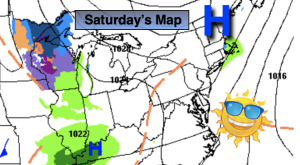
High pressure over Quebec will dominate our weather through today. The sun will rule the sky and readings will be chilly.
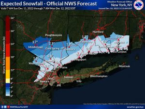
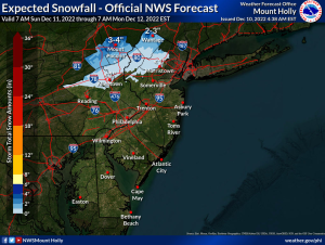
Sunday will feature thickening clouds as a clipper works Southeast from the Great Lakes. Areas of Light rain and light wet snow will break out during the morning. Intermittent light snow is likely Sunday night even at the coast. At this time it doesn’t look like a big deal for the urban corridor but a light accumulation is possible by late Sunday night (maps above). The first accumulations of the season is always is a news maker.
The clipper will deepen and move off the coast Monday. Leftover areas of light snow will greet us in the morning. Clouds will give way to sun during the afternoon.
Tuesday and Wednesday will feature sunshine and chilly readings as another high pressure system affects our region from Canada.
Stay tuned.
Keep it here for a no hype, no nonsense forecast.
Saturday:
Sunny. Chilly. Highs in the lower 40s. Northeast winds at 8-12mph.
Tonight:
Increasing and thickening clouds. Lows in the mid 30s in the City, the 20 inland. Northeast winds at 5mph.
Sunday:
Areas of light rain and light wet snow developing during the morning. Highs around 40º.
Monday:
Intermittent light morning snow giving way to afternoon sun. Highs in the lower 40s.
Tuesday:
Sunny. Chilly. Highs around 40º.
Wednesday:
Mostly sunny. Highs around 40º.