Synopsis:
The forecast will cooperate for the beginning of the week. It’ll be bright and seasonable as high pressure moves off the coast. High clouds will filter the sun later today.
A front will move in from the West on Tuesday. Ahead of it mild air will be brought up from the South. Showers are likely. On and off showers are likely for Wednesday (mainly in the morning) as the front will be sluggish moving off the coast.
A break from the wet conditions is expected for Thursday.
Low pressure will move from the Ohio Valley to the Mid-Atlantic coast on Friday. The timing and positioning of this system is still in question. The potential is there for some rain, but this is not etched in stone.
Stay tuned.
Keep it here for a no hype, no nonsense forecast.
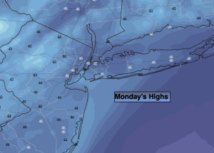
Monday:
Sunny. Seasonable. Highs in the mid to upper 40s. Southwest to Southeast winds at 5mph.
Tonight:
Thickening clouds. Lows in the mid 40s in the City, the 30s inland. Light Southeast wind.
Tuesday:
Mostly cloudy with showers. Mild. Highs in the mid 50s.
Wednesday:
Mostly cloudy with showers. Mild. Highs in the upper 50s.
Thursday:
Mostly sunny. Mild. Highs in the lower to mid 5os.
Friday:
Mostly cloudy. Potential for some rain. Highs in the upper 40s.