Synopsis:
The first half of Saturday will be wet as a cold front approaches. The rain will taper off midday. Peeks of sun are possible during the afternoon. A quick shower is possible around sunset with the passage of the front. It’ll be a mild with readings almost ten degrees above average. The average high is 48º.
It’ll be a clear and cold night as the cold front moves out to sea.
Sunday will be the brighter half of the weekend with sunny skies and chilly readings as another high pressure system works in. A sunny, seasonable start to the workweek is anticipated for Monday.
A front will move in from the West on Tuesday. Ahead of it mild air will be brought up from the South. Showers are likely. On and off showers are likely for Wednesday as the front will be sluggish moving off the coast.
Stay tuned.
Keep it here for a no hype, no nonsense forecast.
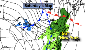
Saturday:
A period of rain likely through midday. Peeks of afternoon sun. Mild. Highs in the mid to upper 50s. Southwest winds increasing to 10-20mph with gusts to 30mph.
Tonight:
Clear. Much colder than last night. Lows in the mid 30s in the City, the 20s inland. Northwest winds at 10-20mph and diminishing.
Sunday:
Sunny. Cooler. Highs in the mid 40s.
Monday:
Sunny. Seasonable. Highs in the mid to upper 40s.
Tuesday:
Mostly cloudy with showers. Mild. Highs in the mid 50s.
Wednesday:
Mostly cloudy with showers. Mild. Highs in the mid 50s.