Synopsis:
Scattered showers are possible this morning as we welcome November as a trough of low pressure moves through. Drier conditions are expected by afternoon. Skies will remain mainly cloudy but some late day sun can’t be ruled out. Temperatures will be mild.
High pressure will strengthen over the Northeast and dominate our area for the beginning of November. Temperatures will be well above the average highs of the upper 50s. Wednesday’s through Saturday’s forecast will be a familiar one with mild to warm readings and sunny skies as high pressure dominates. Indian Summer is on the way for those areas that received a frost or freeze (which is most locations outside the urban corridor). Enjoy!
Stay tuned.
Keep it here for a no hype, no nonsense forecast.
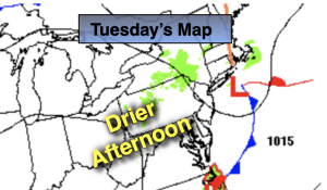
Tuesday:
Scattered morning showers. Remaining mostly cloudy. Some late day sun possible. Mild. Highs in the upper 60s. West to Northwest winds at 5-10mph.
Tonight:
Clearing skies. Lows in the mid 50s in the City, the 40s inland. Northwest winds less than 5mph.
Wednesday:
Sunny. Highs in the upper 60s.
Thursday:
Sunny. Highs in the mid 60s.
Friday:
Sunny. Highs in the upper 60s.
Saturday:
Sunny. Warm. Highs around 70º