Synopsis:
We’re going to have to go through this one more day with grey skies and times of showers. Low pressure will finally begin to pull out into the Atlantic as it weakens today. It will still be raw with readings around ten degrees below the average high of 69º.
Skies will begin to clear tonight as drier air works in.
By Thursday the high to the North will win the battle as low pressure moves offshore. The sun will return and readings will pop into the lower 70s. A dramatic and welcome change.
Friday will be a Fall classic with plenty of sun and mild readings ahead of a cold front.
Behind the front on Saturday readings will be several degrees below the average high of 68º despite the sunhine.
Sunday will be bright and cool as high pressure works in.
Keep it here for a no hype, no nonsense forecast.
Wednesday:
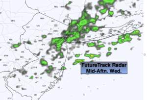
On and off showers. Very cool. Highs in the upper 50s to around 60º. North to Northwest winds at 8-12mph.
Tonight:
Clearing skies. Lows in the mid 50s in the City, the upper 40s inland. North to Northwest winds at 5mph.
Thursday:
Sunny. Warmer. Highs in the lower 70s.
Friday:
Sunny. Mild. Highs in the lower to mid 70s.
Saturday:
Mostly sunny. Cooler and breezy. Highs only around 60º.
Sunday:
Sunny. Highs in the lower to mid 60s.