Synopsis:
A weakening front will move through the area today. A mix of sun and clouds is expected. An isolated shower or storm is possible but the majority of day will be dry. Highs will be just above the average high of 83º.
Wednesday thorough Friday will feature high pressure building over the region. It’ll become hot, but nothing too extreme is expected.
Saturday will be pleasant under a mix of sun and clouds as the next front approaches from the Northwest.
Keep it here for a no hype, no nonsense forecast.
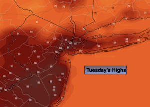
Tuesday:
Sun and clouds. An isolated PM storm is possible. Highs in the mid 80s. Southwest to West winds at 5-10mph.
Tonight:
Mostly clear. Lows around 70º in urban areas, the 60s North and West. West to Northwest winds at 5mph.
Wednesday:
Sunny and warm. Highs in the upper 80s.
Thursday:
Sunny and hot. Highs around 90º.
Friday:
Sunny and hot. Highs around 90º.
Saturday:
Sun and clouds. Highs in the mid 80s.
Catch me Sunday on the Fox Business Network from 6am-9am and on the Weather Stream until 10am. Find us on Tubi, Roku TV and YouTube TV and as always the Fox Weather App. It’s Free!