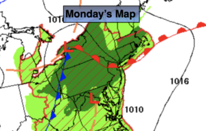
Synopsis:
Much needed rain will fall over many areas today as low pressure over Western New York drags a warm front through the region. It won’t be raining all the time, showers and storms will be scattered with local downpours. Some lucky regions may pick up a couple of inches while others may miss out on significant rainfall. It’ll be humid but temperatures will be several degrees below the average high of 83º due to the rain cooled air.
A Spotty shower and an isolated storm is possible overnight.
By Tuesday this system should pull to the North and East as a weakening front moves through. Isolated showers are still possible, but skies should brighten during the afternoon. The majority of Tuesday will be dry.
Wednesday thorough Friday will feature high pressure building in from the West. Bright, warm conditions are expected.
Keep it here for a no hype, no nonsense forecast.
Monday:
Mostly cloudy with scattered showers and storms. Local downpours. Humid. Highs in the upper 70s. East winds at 5mph
Tonight:
Mostly cloudy. Scattered Showers and isolated storms possible. Lows around 70º in urban areas, the 60s North and West. Southeast t0 East winds less than 5mph.
Tuesday:
Spotty showers possible, otherwise clouds giving way to brighter skies. Highs in the mid 80s.
Wednesday:
Sunny and warm. Highs in the mid to upper 80s.
Thursday:
Sunny and hot. Highs in the upper 80s to lower 90s.
Friday:
Sunny and warm. Highs in the upper 80s.
Catch me Sunday on the Fox Business Network from 6am-9am and on the Weather Stream until 10am. Find us on Tubi, Roku TV and YouTube TV and as always the Fox Weather App. It’s Free!