Synopsis:
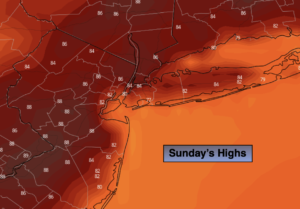
The weekend will feature higher humidity levels, under a mix of sun and clouds as high pressure slips offshore. Sunday’s readings will be seasonable in the mid 80s.
Showers and isolated storms will move in overnight as a system work our way from the West.
On Monday weak low pressure over the Ohio Valley should draw moisture up from the South. Scattered showers and storms are in the forecast. Lets keep our fingers crossed as many areas desperately need the rain.
By Tuesday this system should pull to the North and East. Scattered showers are still possible, but skies should brighten during the afternoon.
Wednesday and Thursday will feature high pressure building in from the West. Bright, warm conditions are expected.
Keep it here for a no hype, no nonsense forecast.
Sunday:
Partly sunny. Humid. Cooler at the coast. Highs in the mid 80s. Southeast 5-10mph.
Tonight:
Mostly cloudy. Showers and isolated storms developing. Lows around 70º in urban areas, the 60s North and West. Southeast t0 East winds less than 5mph.
Monday:
Mostly cloudy with scattered showers and storms. Humid. Highs in the lower 80s.
Tuesday:
Morning showers possible, otherwise clouds giving way to brighter skies. Highs in the mid 80s.
Wednesday:
Sunny and warm. Highs in the mid 80s.
Thursday:
Sunny and warm. Highs in the upper 80s.
Catch me Sunday on the Fox Business Network from 6am-9am and on the Weather Stream until 10am. Find us on Tubi, Roku TV and YouTube TV and as always the Fox Weather App. It’s Free!