Synopsis:
We’ll be two for two this weekend as high pressure moving offshore will be responsible for our fine August weather. Expect a mix of sun and high clouds today. It’ll be warm with low humidity. Readings will be cooler at the coast as the wind turns off the ocean.
Our low confidence forecast of the last couple of days for tomorrow through Wednesday is not becoming more clear. Weak low pressure will be over the region Monday and Tuesday. A mix of clouds and sun is expected with a spotty shower possible. Wednesday this low will become more organized offshore and move into Eastern New England. Confidence has now increased that the beneficial rains of this system will miss the NYC tri-state area. We desperately need the rain. Again, showers are possible but at this time nothing steady or heavy is expected.
By Thursday this system will be far enough North resulting in a partly sunny day with seasonable readings.
Stay tuned.
Keep it here for a no hype, no nonsense forecast.
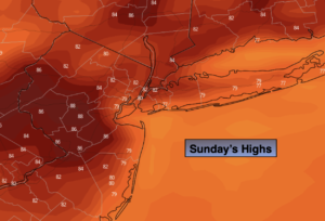
Sunday:
Sun and high clouds. Highs in the lower to mid 80s. Cooler at the coast. Northeast to South winds at 5-10mph.
Tonight:
Partly cloudy. Lows in the upper 60s in urban areas, the 50s and 60s North and West. Light South wind.
Monday:
Mostly cloudy with the chance of spotty showers. Highs in the upper 70s.
Tuesday:
Mostly cloudy with the chance of scattered showers. Highs in the upper 70s.
Wednesday:
Mostly cloudy with the chance of showers. Highs in the upper 70s.
Thursday:
Partly sunny. Highs in the lower 80s.
Catch me on the Fox Business Network from 6am-9am Sunday and on the Fox Weather Stream until 10am. Find us on Tubi, Roku TV and YouTube TV and as always the Fox Weather App. It’s Free!