Synopsis:
It’ll be a very warm to hot Wednesday with moderate levels of humidity. Typical mid July conditions are expected as high pressure to our West will be influencing our weather the next several days.
A very weak frontal boundary offshore on Thursday may spark a spotty shower or storm. The majority of the day will be rain-free under a mix of clouds and sun.
The high will move to our North Friday and into the weekend. Temperatures under a bright sky will be just above the average high of 85º. Some fine mid Summer weather will be had!
Stay tuned.
Keep it here for a no hype, no nonsense forecast.
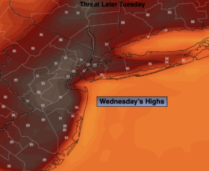
Wednesday:
Mostly sunny. Very warm to hot. Highs in the upper 80s to lower 90s. Cooler at the coast when the sea breeze kicks in. Northwest to South winds at 5-10mph.
Tonight:
Mostly clear. Lows in the lower 70s in the City, the 60s North and West. South to North winds diminishing to 5mph.
Thursday:
Partly Sunny. Isolated showers or storms are possible. Highs in the mid 80s.
Friday:
Mostly Sunny. Highs in the mid 80s.
Saturday:
Mostly Sunny. Highs in the mid to upper 80s.
Sunday:
Partly Sunny. Highs in the mid to upper 80s.
Catch me on the Fox Business Network this weekend until 9am Weather Stream until 10am. Find us on Tubi, Roku TV and YouTube TV and as always the Fox Weather App. It’s Free!