Synopsis:
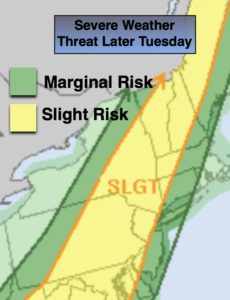
It’ll heat up today as a well developed Southwesterly wind around the high takes hold. Readings will be around 90º in many areas and there will be a noticeable increase in humidity. Scattered thunderstorms are possible toward evening with an approaching cool front. Some of the storms may be severe especially North and West from the coast. Keep an eye to the sky for threatening weather after 4pm.
Any storms will end early tonight. Skies will become partly cloudy.
Wednesday through Saturday won’t be as hot or humid as the heat bubble moves offshore. Temperatures will be around or just above the average high of 85º. There will be a weak disturbance moving through on Thursday with more clouds and a threat of a few showers, otherwise skies will mainly be sunny into Saturday.
Stay tuned.
Keep it here for a no hype, no nonsense forecast.
Tuesday:
Hazy, hot and humid. Breezy. Highs in the lower 90s. Cooler at the coast. Scattered storms possible toward evening. Southwest winds at 10-20mph.
Tonight:
Scattered storms early, otherwise clearing skies. Lows in the lower 70s in the City, the 60s North and West. Southwest to Northwest winds diminishing to 5mph.
Wednesday:
Mostly sunny. Very warm. Not as humid. Highs in the upper 80s.
Thursday:
Partly Sunny. Scattered showers are possible. Highs in the mid 80s.
Friday:
Mostly Sunny. Highs in the mid 80s.
Saturday:
Mostly Sunny. Highs in the mid 80s.
Catch me on the Fox Business Network this weekend until 9am Weather Stream until 10am. Find us on Tubi, Roku TV and YouTube TV and as always the Fox Weather App. It’s Free!