Synopsis:
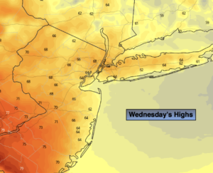
June’s debut on Wednesday will feature a mix of clouds and some sun. Readings will be twenty five degrees cooler than Tuesday’s 90s with a wind off the cooler Atlantic. Readings will be cooler than the City to the East and much warmer to the West.
Two disturbances will ride rapidly through our region tonight and then again on Thursday afternoon and night. Scattered showers and storms are possible during these times. During the day on Thursday partly sunny skies are expected with a pop in temps. Readings in many areas will reach 80º or above. Once again it’ll be cooler by the coast.
Friday will be decent as the system moves off the coast. Any clouds will give way to sunny skies.
The first weekend of June will spectacular as high pressure dominates. Both days will feature abundant sunshine with readings near of just above the seasonal highs of the mid to upper 70s.
Stay tuned.
Keep it here for a no hype, no nonsense forecast.
Wednesday:
Clouds and sun. Much cooler. Highs in the upper 60s in the City, much warmer to the West, cooler to the East. East to Southeast winds at 5-10mph.
Tonight:
Scattered showers and a slight chance of a thunderstorm. Lows in the lower 60s in the City around 60º inland. Light South winds.
Thursday:
Sun and clouds. Much warmer. Late day scattered storms possible. Highs around 80º. Cooler at the coast.
Friday:
Clouds to sun. Highs in the mid to upper 70s.
Saturday:
Sunny. Highs in the mid to upper 70s.
Sunday:
Sunny. Highs in the mid to upper 70s.
Catch me on the Fox Weather Stream from 10am-1pm Wednesday. Find us on Tubi, Roku TV and YouTube TV and as always the Fox Weather App. It’s Free!