Synopsis:
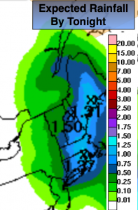
A weak area of low pressure will affect the region today with periods of rain. The heaviest and steadiest rain will be along the coast and East of the City (expected rainfall map above). In fact some of our Western counties may receive little if any rain while Connecticut and Long Island can expect over a half inch to possible an inch. Tranquil conditions will return mid to late week with above average readings.
There a signs that an energized trough will develop along the East coast by next Sunday. This will most likely bring down some of the coldest air this season so far.
Today:
Periods of rain, especially at the coast and East of the City. Little if any rain may fall well North and West. Highs mainly in the 40s. The lower 50s where the rain doesn’t fall. North wind at 10-20mph.
Tonight:
Any evening showers will end by the coast, otherwise becoming partly cloudy. Lows in the mid 40s in the City, the 30s inland. Northwest wind at 5-10mph.
Wednesday:
Partly sunny. Highs in the mid to upper 50s.
Thursday:
Sunny with readings near 60º.
Friday:
Sunny with highs in the lower 60s.
Saturday:
Partly sunny with readings in the lower 60s.
Stay Tuned.
Keep it here for a no nonsense, no hype forecast.