Synopsis:
Chilled sunshine will be with us once again today as the Northwesterly flow continues. This will result in our continuation of below average temperatures (although it won’t be as cool as yesterday). We’ll be five to seven degrees below the average high of 67º.
Saturday will be bright with the breeze not being an issue as high pressure moves overhead. We greet May on Sunday and readings will finally feel like they should for this time of the year!
The next chance of showers comes Monday as a weakening front moves through. Tuesday will feature abundant sunshine and seasonable temperatures with high pressure moving overhead.
Stay tuned.
Keep it here for a no hype, no nonsense forecast.
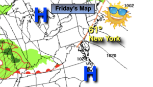
Friday:
Mostly sunny, breezy and cool. Highs around 60º. Northwest winds at 15-25mph.
Tonight:
Mostly clear. Lows in the lower 40s in the City, near freezing inland. Northwest wind 10-20mph and diminishing.
Saturday:
Sunny. Highs in the mid 60s.
Sunday:
Mostly sunny. Highs in the upper 60s.
Monday:
Mostly cloudy with scattered showers. Highs in the lower 60s.
Tuesday:
Sunny. Highs in the upper 60s.
Catch me on the Fox Weather Stream Friday from 10am-1pm. Find us on Tubi, Roku TV and YouTube TV and as always the Fox Weather App. It’s Free!