Synopsis:
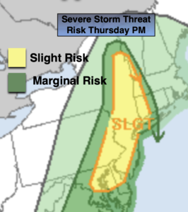
After a Summer-like day for many just West of the City scattered showers and storms will develop by mid to late afternoon. Some of the storms may become strong to isolated severe. Keep an eye to the sky for threatening weather. Skies will clear overnight with cooler readings being had by all.
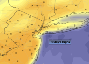
Friday should be mild under sunny skies as high pressure builds to our Southeast. Highs will be a several degrees above the average high of 62º. It will be a delightful day! Passover begins at sundown which occurs at 7:35pm EDT.
The Easter Holiday weekend should be decent. Partly sunny skies are expected both days. A shower can’t be ruled out later Saturday with the passage of a cold front. Dry Easter bonnets are expected Sunday as high pressure moves in. Temperatures will be a few degrees above the average on Saturday. A chilly breeze will be with us on Easter with readings several degrees below average.
Sun to give way to clouds on Monday as a system begins to move in from the South. Rain is likely Monday night into Tuesday morning as low pressure develops just offshore.
Stay tuned.
Keep it here for a no hype, no nonsense forecast.
Tonight:
An evening shower or storm, otherwise mostly clear. Lows around 50º in the City, the upper 30s and 40s inland. Northwest to West winds 10-15mph and diminishing.
Friday:
Sunny. Highs in the upper 60s. West to Southwest winds at 10-20mph.
Saturday
Sun and clouds. Scattered afternoon showers. Highs in the mid 60s.
Easter Sunday:
Party sunny, breezy and cooler. Highs in the mid 50s.
Monday:
Sun to clouds. Highs in the mid 50s.
Tuesday:
Morning rain to afternoon sun. Highs in the mid 50s.
Catch me on the Fox Weather Stream from 6am-10am Friday. Find us on Tubi, Roku TV and YouTube TV and as always the Fox Weather App. It’s Free!