Synopsis:
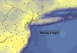
High pressure will move off the Southeast coast today. This will result in plenty of sunshine more seasonable readings. The average high temperature is 60º.
Clouds will increase tonight ahead an approaching warm front. Isolated showers are possible.
The warm front will push through Tuesday morning with scattered showers. Behind the front skies will become mostly sunny and readings will pop to around 70º.
Pleasant conditions will continue into Wednesday but with a wind off the cooler Atlantic readings will be about five degrees cooler than Tuesday.
A cool front will approach Thursday. Ahead of the system temperatures will once again pop into the 70s. Showers are possible with the passage of the front during the late afternoon.
Friday should be pleasant under a mix of sun and clouds. Highs will be a few degrees above average.
Stay tuned.
Keep it here for a no hype, no nonsense forecast.
Monday:
Mostly sunny. Highs around 60º. Northwest to Southwest winds at 8-12mph.
Tonight:
Mostly cloudy. Isolated showers. Lows in the 40s throughout. South wind less than 5mph.
Tuesday:
Scattered morning showers, otherwise becoming mostly sunny and Warm. Highs around 70º.
Wednesday:
Partly sunny. Highs in the mid 60s.
Thursday:
Partly sunny. Warmer. Late day showers. Highs in the mid 70s.
Friday:
Partly sunny. Highs in the mid 60s..
Catch me on the Fox Weather Stream from 1pm-4pm on Monday. Find us on Tubi, Roku TV and YouTube TV and as always the Fox Weather App. It’s Free!