Synopsis:
An upper level low will continue to affect the Northeast today.This will result in changeable conditions. Today will feature a mix of sun and clouds. An isolated shower can’t be ruled out later in the day. It’ll still be cool with readings several degrees below the average high of 59º.
On Monday high pressure will replace low pressure. This will result in plenty of sunshine more seasonable readings.
Tuesday will be mild as a Southwest flow develops around high pressure moving off the Southeast coast. Pleasant conditions will continue into Wednesday.
A cool front will approach Thursday. Ahead of the system temperatures will pop into the 70s. Showers are possible with the passage of the front during the late afternoon.
Stay tuned.
Keep it here for a no hype, no nonsense forecast.
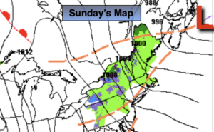
Sunday:
Sun and clouds. Cool. An isolated late day shower. Highs in the lower to mid 50s. Northwest winds at 10-20mph with higher gusts.
Tonight:
Mostly clear. Lows around 40º in the City, near 30º well inland. Northwest winds at 10-20mph. Winds will diminishing.
Monday:
Mostly sunny. Highs in the upper 50s.
Tuesday:
Clouds and sun. Milder. Highs in the upper 60s.
Wednesday:
Partly sunny. Highs in the mid 60s.
Thursday:
Partly sunny. Warmer. Late day showers. Highs in the mid 70s.
Catch me on the Fox Business Network this weekend from 6-9am and on Fox Weather Stream until Noon. Find us on Tubi, Roku TV and YouTube TV and as always the Fox Weather App.