Synopsis:
An upper level low will move over the Northeast this weekend. This will result in cool readings and scattered showers today. A thunderstorm is possible. There will be dry times. Sunday will be the better half of the weekend under a mix of sun and clouds. An isolated shower can’t be ruled out later in the day. It’ll still be cool.
On Monday high pressure will replace low pressure. This will result in plenty of sunshine and pleasant readings.
Tuesday will be mild as a Southwest flow develops around high pressure moving off the Southeast coast. Pleasant conditions will continue into Wednesday.
Stay tuned.
Keep it here for a no hype, no nonsense forecast.
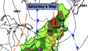
Saturday:
Mostly cloudy with scattered showers. Chance of a thunderstorm. Highs in the mid to upper 50s. Winds becoming West at 8-15mph.
Tonight:
Mostly cloudy with scattered showers early. Lows in the lower 40s in the City, the 30s inland. Northwest winds at 8-12mph.
Sunday:
Sun and clouds. Cool. An isolated late day shower. Highs in the lower to mid 50s.
Monday:
Mostly sunny. Highs around 60º.
Tuesday:
Partly sunny. Milder. Highs in the mid to upper 60s.
Wednesday:
Partly sunny. Mild. Highs in the mid 60s.
Catch me on the Fox Business Network this weekend from 6-9am and on Fox Weather Stream until Noon. Find us on Tubi, Roku TV and YouTube TV and as always the Fox Weather App.