Synopsis:
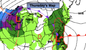
Round two of the rain will work in this morning as a second system moves in from the South and West. The rain will begin during the mid morning to midday hours from West to East and continue on and off throughout the day. The rain cloud be heavy at times by evening especially over Northwestern areas. Readings will be several degrees below the average high of 57º.
Rain tonight, possibly heavy early to the North and West. The rain will taper off late.
The low will move off the coast early Friday morning. The sun will return and readings for a change will be above average.
An upper level low will move over the Northeast this weekend. This will result in cool readings and scattered showers on Saturday. There will be dry times. Sunday will be the better half of the weekend under a mix of sun and clouds. It’ll still be cool.
On Monday high pressure will replace low pressure. This will result in plenty of sunshine and pleasant readings.
Stay tuned.
Keep it here for a no hype, no nonsense forecast.
Today:
On and off rain. Highs in the lower 50s. East winds at 15-25mph.
Tonight:
Rain, heavy at times, especially North and West. The rain will taper off late. Lows in the 40s throughout. East to West winds at 5-10mph.
Friday:
Sun and clouds. Milder than recent days. Highs in the lower 60s.
Saturday:
Mostly cloudy with scattered showers. Breezy. Highs in the mid to upper 50s.
Sunday:
Sun and clouds. Cool. Highs in the lower to mid 50s.
Monday:
Mostly sunny. Highs around 60º.
Catch me on the Fox Weather Stream from 10am-1pm on Thursday. Find us on Tubi, Roku TV and YouTube TV and as always the Fox Weather App.