
Synopsis:
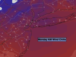
Scattered flurries this evening will give way to partly cloudy skies tonight. An Arctic airmass will move in accompanied by gusty winds and frigid temperatures. Lows will fall to the upper teens and lower 20s. Windchills will be in the single digits and teens by morning. A shock to say the least.
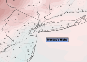
Monday will feel more like Winter than Spring as a Canadian air settles over the region. Readings will remain in the upper 20s to lower 30s for highs and the wind will add a bite.
Tuesday won’t be as harsh but the chill will continue as high pressure slides over the region.
On Wednesday a warm front will approach. More clouds than sun is expected. Readings will be a few degrees below the average high of 53º.
Thursday will feature warm readings ahead of a cool front. Temperatures will be more the ten degrees higher than the average high. A big change for sure. Showers are possible during the afternoon.
Behind the front on Friday which is the first day of April, it’ll be partly sunny and mild.
Stay tuned.
Keep it here for a no hype, no nonsense forecast.
Catch me on the Fox Weather Stream between 1pm-4pm on Monday. Find us on Tubi, and YouTube TV and as always the Fox Weather App.
Tonight:
Evening scattered snow showers, otherwise skies will be partly cloudy. Frigid Lows in the lower 20s in the City, the upper teens inland. Wind chills in the single digits and teens. Northwest winds at 15-25mph with higher gusts.
Monday:
Mostly sunny, breezy and cold. Highs only in the lower to mid 30s. Morning wind chills in the single digits and teens. Northwest winds at 15-25mph with higher gusts.
Tuesday:
Mostly sunny. Chilly. Highs in the mid 40s.
Wednesday:
Sun and clouds. Cool. Highs in the upper 40s.
Thursday:
Mostly cloudy. Warmer. Showers possible during the afternoon. Highs in the mid 60s.
Friday:
Partly sunny and mild. Highs around 60º.