Synopsis:
Mostly sunny, breezy conditions are expected today as weak high pressure sits over the areas. It’ll be mild with highs about ten degrees above average high of 52º.
Saturday, an upper level low will move through the Northeast. This will result in an unstable atmosphere. Clouds will win the battle and scattered showers are possible anytime after mid-morning. Readings will be near slightly above average.
A blast of Canadian air will usher in behind another cold front on Saturday night. This will set the stage for a blustery Sunday. A mix of clouds and sun is expected. Highs will only be in the 40s.
Monday will be a cold Spring day with readings not getting out of the 30s for highs. Tuesday won’t be as harsh but the chill will continue. Yep, Spring in the Northeast.
Stay tuned.
Keep it here for a no hype, no nonsense forecast.
Catch me on the Fox Business Network this weekend between 6am-9am and on Fox Weather Stream between 6am-Noon. Find us on Tubi, and YouTube TV and as always the Fox Weather App.
Friday:
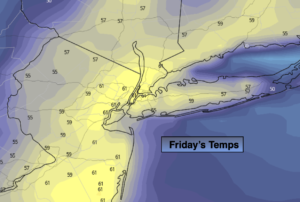
Mostly sunny. Milder. Highs in the lower 60s. West winds at 8-15mph.
Tonight:
Partly cloudy. Lows in the mid 40s in the City, the 30s elsewhere. West winds at 5-10mph.
Saturday:
More clouds than sun. Spotty showers. Highs in the mid 50s.
Sunday:
Partly sunny. Windy and cooler. Highs in the mid 40s.
Monday:
Mostly sunny. Windy and cold. Highs only in the 30s.
Tuesday:
Mostly sunny. Still chilly. Highs only in the 40s.