Synopsis:
We’ll have one more beauty today. The sun will dominate and readings once again will be above the average high of 51º.
The next chance of showers will come later tomorrow and continue on and off through Friday. The culprit is a front that will move into the region and then stall. Low pressure looks to develop along the front on many of the weather models. This will keep our shower chance continuing to the end of the week. It doesn’t look like it will be wet all of the time.
Saturday will feature another low developing offshore. This will result in a blustery day under a mix of sun and clouds. At this time, showers are not in the forecast.
Stay tuned.
Keep it here for a no hype, no nonsense forecast.
Catch me on Fox Weather Stream from Noon-4pm Tuesday. Find us on Tubi, and YouTube TV and as always the Fox Weather App.
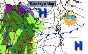
Tuesday:
Mostly sunny. Highs in the mid 50s. Northwest winds 8-12mph.
Tonight:
Partly cloudy. Lows around 40º in the City, the 20 and 30s elsewhere. North to Northeast winds at 5mph.
Wednesday:
Mostly cloudy with showers likely by afternoon. Cooler. Highs in the upper 40s.
Thursday:
Scattered showers. Highs in the lower 50s.
Friday:
Mostly cloudy. Showers are possible. Highs in the upper 50s.
Saturday:
Partly sunny. Breezy. Highs in the mid 50s.