Synopsis:
High pressure will move off the coast this weekend. The return Southwesterly flow will bring temperatures to near seasonal levels today (the average high is in the mid 40s). Sunday’s readings will be more common for late April as a warm push moves up from the South. In fact, we’ll be flirting with record highs. The record for Central Park is 68º set in 1935. Spotty showers are possible during the morning, but much of the afternoon should be dry. Both weekend days will feature a mix of clouds and sun.
We’ll continue with our Spring preview theme on Monday. Highs may approach 70º, especially from the City and to the South and West. Low pressure will work up and to our West. Any sunshine will give way to clouds and the threat late day rain. Rain is likely Monday night with the passage of the front.
There will be no Arctic air with this front. Both Tuesday and Wednesday will feature a decent amount of sunshine with readings a couple degrees above average.
Keep it here for a no hype, no nonsense forecast.
Catch me on the FOX Business Network from 6-9am Saturday and Sunday and on the Fox Weather Stream/App until Noon!
Saturday:
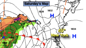
Sun and clouds. Seasonal. High in the mid 40s. South winds at 5mph.
Tonight:
Mostly cloudy. Lows in the lower 40s in the City, the 30s inland. Southeast winds less than 5mph.
Sunday:
Mostly cloudy. Very warm. Spotty morning showers. High in the mid 60s.
Monday:
Mostly cloudy. Balmy. Late day rain is likely. Highs around 70º. Cooler North, warmer South.
Tuesday:
Mostly sunny. Mild. Highs around 50º.
Wednesday:
Sun to clouds. Highs around 50º.