Synopsis:
Tonight will be very cold with readings well below freezing under clear skies and diminishing winds as Arctic high pressure moves into the region.
Cold sunshine will dominate on Friday.
High pressure will move off the coast this weekend. The return Southwesterly flow will bring temperatures to seasonal levels on Saturday. The average high temperature is 46º. Sunday’s readings will be more common for late April as a warm push moves up from the South. A front will approach from the West on Sunday. Spotty showers are possible during the afternoon, but much of the time should be dry. Both weekend days will feature a mix of clouds and sun.
We’ll continue with our Spring Preview theme on Monday. Another area of low pressure will work up and to our West with a threat late day rain. Rain is likely Monday night into Tuesday morning as the system moves off the coast.
Keep it here for a no hype, no nonsense forecast.
Tonight:
Clear and very cold. Lows around 20º in the City, 10º-20º inland. Northwest winds at 10-20mph and diminishing.
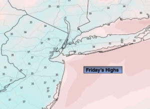
Friday:
Sunny. Cold. High in the mid to upper 30s. Northwest to West winds at 5-10mph.
Saturday:
Mostly sunny. Seasonal. High in the mid 40s.
Sunday:
Mostly cloudy. Very warm. Spotty afternoon showers. High in the mid 60s.
Monday:
Mostly cloudy. Balmy. Afternoon rain is likely. Highs in the lower 60s.
Tuesday:
Morning rain. Some afternoon sun. Still mild. Highs in the lower 50s.