Synopsis:
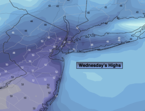
High pressure over the region today will result in a bright and mild Wednesday. Readings will get above the average high of 46º.
A cold front will move in tonight. Scattered rain and snow showers are possible after midnight. Lows will be in the 30s throughout.
Thursday will be bright but the wind will be busy adding a bit of a bite. Readings will be steady and then fall into the 30s during the afternoon.
Cool readings are expected for the rest of the week into the beginning of the weekend with the sun dominating.
High pressure will move off the coast and a front will approach from the West on Sunday. Temperatures will pop to Spring-time levels. Showers are possible during the afternoon.
Keep it here for a no hype, no nonsense forecast.
Wednesday:
Mostly sunny. Mild. High in the 40s to around 50º. Northwest to West winds at5-10mph.
Tonight:
Mostly cloudy with scattered rain and snow showers late. Lows in the 30s throughout. Southwest to West winds 5-10mph.
Thursday:
Mostly sunny. Breezy and Colder. High around 40º with readings falling into the 30s later in the day.
Friday:
Mostly sunny. High in the upper 30s.
Saturday:
Mostly sunny. High in the lower to mid 40s.
Sunday:
Mostly cloudy. Balmy. Scattered afternoon showers. High in the lower 60s.