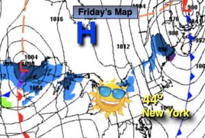
Synopsis:
A rapidly moving cold front will move offshore early this morning with a few minutes of heavy rain and high winds, otherwise the sun will return today. Readings will still be mild in the morning but temperatures will fall some in the afternoon. Winds will be strong gusting up to 40mph at times.
Tonight will be cold as a Northwest wind brings down Canadian air. All areas will be well below freezing.
The Presidents’ Day holiday weekend in general will be tranquil. Saturday will feature an approaching Arctic front moving through during the afternoon. A mix of sun and clouds is expected. As the front moves through it will be accompanied by rain showers and possibly a few snow squalls. Readings will be near the seasonal average of 43º.
Saturday night will be bitterly cold with a biting wind. Lows will be in the teens.
It’ll be a bright Sunday but despite the sunshine readings will struggle to get above freezing.
On Presidents’ Day a mild push will arrive as winds turn to the Southwest. Highs will be ten degrees above average under abundant sunshine.
Low pressure will head toward the region Tuesday. Thickening clouds and showers are expected by afternoon. It’ll still be mild.
Stay tuned.
Friday:
Early morning rain and gusty winds, otherwise mostly sunny. Highs falling into the 40s. Remaining windy. Northwest winds at 15-25mph with gusts to 45mph.
Tonight:
Clear. Much colder than last night. Lows 20s throughout (not the 60s of 24 hours ago). Northwest to Southwest winds diminishing to 5-10mph.
Saturday:
Sun and clouds. Afternoon rain showers and possible snow squalls . Highs in the lower 40s. Becoming windy during the afternoon.
Sunday:
Mostly sunny. Much colder. Highs in the lower to mid 30s.
Monday:
Mostly sunny. Milder. High in the lower to mid 50s.
Tuesday:
Thickening clouds. Afternoon showers possible. Mild. High in the mid 50s.