Synopsis:
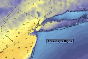
A deep Southerly flow around Atlantic high pressure will result in Spring-like readings under a mix of clouds and some sun today. Highs will be around 60º. Readings may pop into the lower 60s if enough sun shines. Any showers should hold off until later this evening as a significant front makes it’s approach. Winds will begin to increase out of the South later this afternoon.
Rain is likely tonight as the front sweeps through. Strong gusty winds will accompany the front. Gusts up to 50mph are possible in most areas, with gusts up to 60mph possible at the coast and over Long Island.
An early morning shower is possible Friday, otherwise the sun will return. Readings on Friday will still be mild in the morning but temperatures will fall some in the afternoon.
The Presidents’ Day holiday weekend looks bright and tranquil with near seasonal temperatures as high pressure dominates thorough Sunday. By Monday, another mild push will greet us. Temperatures should get to well above the averages.
Stay tuned.
Thursday:
Mostly cloudy. Balmy. Winds will increase during the afternoon. Showers are possible by evening. Highs around 60º. South to Southwest winds increasing to 10-20mph with gusts to 30mph.
Tonight:
Rain possibly heavy at times. Windy and mild. Lows in the 40s and 50s throughout. Southwest winds at 15-30mph with gusts between 50mph and 60mph.
Friday:
Early morning rain, otherwise mostly sunny. Highs in the mid 50s. Temperatures will fall during the afternoon.
Saturday:
Mostly sunny. Highs in the mid 40s.
Sunday:
Sunny. Highs in the lower 40s.
Monday:
Mostly sunny. Milder. High in the lower 50s.