
Synopsis:
We are back to reality with Winter. An area of low pressure will develop with an offshore cold front. Snow will fall through the mid morning then taper off from West to East from late morning through early afternoon. A general one to three inches is now expected in most areas. These amounts will be reached on colder surfaces with pavements and concrete surfaces receiving less. Conditions will improve drastically by later afternoon and by kickoff time for the Super Bowl. Temperatures will be well below the average high of 42º; it’ll actually be around freezing for highs today. It will be a shock after our warm spell.
Tonight will be frigid with all area readings in the teens to around 20º in urban areas. Use caution on untreated surfaces.
Monday will be very cold with readings remain in the 20s as Arctic high pressure dominates.
By Tuesday many areas should approach or crack freezing under sunny skies.
High pressure will move offshore by midweek. A return Southwesterly flow will cause readings once again to pop to Springtime levels. Any showers should hold off until later Thursday as a significant front makes it’s approach.
Stay tuned.
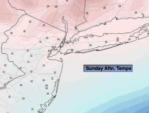
Sunday:
Cloudy. Much colder. Light snow. The snow will taper off during midday to early afternoon. The sun may return later in the day. Highs around freezing. North wind at 8-12ph.
Tonight:
Clear, breezy and frigid. Lows in the upper teens in the City, the lower to mid teens inland. Wind chills in the single digits. Northwest winds at 10-20mph.
Monday:
Mostly sunny, windy and very cold. Highs in the upper 20s.
Tuesday:
Sunny. Highs in the lower to mid 30s.
Wednesday:
Mostly sunny. Milder. Highs in the upper 40s.
Thursday:
Mostly cloudy. Balmy. Showers possible later in the day. Highs mourned 60º.