Synopsis:
Areas of dense fog this morning. Today will be Spring-like with periods of rain. Readings will be almost ten degrees higher then the average high of the upper 30s.
Rain will continue tonight. Well inland, the rain will turn to freezing rain as temperatures fall to freezing or below. Icing will become an issue toward morning on untreated surfaces.
On Friday, the cold front will pass through the region as low pressure travels along it. Rain will possibly change over to wintry precipitation (away from the I-95 corridor) depending on how much cold air bleeds into the system. The potential is there for sleet and freezing rain even to the coast during the day. Icing may become an issue as temperatures will plummet on Friday to below freezing. The best chance for accumulation of ice is North and West of the City. Please use caution.
No matter the outcome, Saturday will feature another bitter blast with readings below freezing. At least the sun will be shining!
Sunday will most likely crack freezing in many areas under a mix of sun and clouds as high pressure begins to move off the coast.
Monday will be quite pleasant for early February with readings near 40º under a mix of sun and clouds.
Stay tuned.
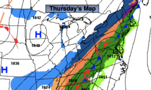
Thursday:
Cloudy with periods of rain. Mild. Highs in the mid to upper 40s. Light winds.
Tonight:
Periods of rain. Rain will most likely go over to freezing rain well inland toward morning. Lows in the 40s then falling into the 30s. Falling to near or below freezing well inland late. South to North winds at 5-10mph.
Friday:
Rain along the coast possibly changing to sleet or freezing rain. Freezing rain, sleet and snow inland. Colder. Highs in the 30s with readings falling during the day. Temperatures falling into the 20s North and West.
Saturday:
Mostly sunny. Much colder. Highs in the upper 20s.
Sunday:
Partly sunny. Highs in the lower 30s.
Monday:
Partly sunny. Highs around 40º.