Synopsis:
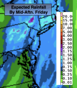
A significant cold front will move through with wind and rain today. It will be a quick hitter-about six hours. Rain, some of which will be heavy, and gusty winds will develop during the mid morning hours and continue into the early to mid afternoon. A half inch to an inch and one half of total rainfall is expected (map above). It’ll be balmy, with temperatures nearly ten degrees above average. The front will be moving rapidly. The sun looks to return for many areas later in the day.
Saturday will feature a mix of sun and clouds. Readings will be more seasonal. Scattered showers are possible by late day and at night as upper level energy swings through and low pressure develops over the region.
Sunday will be a typical November day under a mix of sun and clouds with readings a few degrees below average.
On Monday, weak low pressure will develop near the region. More clouds than sun is expected with scattered showers.
Tuesday will be bright and chilly as Canadian high pressure moves in.
Stay tuned.
Friday:
Mostly cloudy with a period of rain, the rain will be heavy at times. It’ll be breezy and balmy. Late afternoon sun is possible. Highs in the mid 60s. South to West winds at 10-20mph with gusts to 30mph.
Tonight:
Clear. Lows near 50º in the City, the 30s and 40s inland. Northwest to Northeast winds less than 5mph.
Saturday:
Partly sunny, breezy and cooler. Chance of showers by late day. Highs in the upper 5os.
Sunday:
Partly sunny. Cooler. Highs in the lower 50s.
Monday:
Clouds and sun. Scattered showers possible. Highs in the lower 50s.
Tuesday:
Mostly sunny. Chilly. Highs in the upper 40s.