Synopsis:
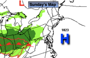
High pressure will be over the Mid-Atlantic coast on Sunday. This will result in mainly sunny skies. Clouds will roll in later in the afternoon as a warm front out West heads in our direction. Highs will be just below the average high of 62º.
It will become unsettled early this week with low pressure developing over the Mid-Atlantic. A warm front will swing to our North Monday morning. A spot shower is possible at this time. It now looks like the majority of the day will be dry with a mix of clouds and sun. It’ll be warm.
The potential for a steadier rain and heavier rain is increasing for Tuesday into early Wednesday as the models are now developing a storm over the region.
Morning rain on Wednesday should give way to some late day sun as the storm pulls offshore. It’ll be breezy to windy as the storm intensifies and moves Northeast.
Thursday we’ll dry out as the sun dominates as high pressure moves in .
Keep it here for a no hype-no nonsense forecast.
Stay tuned.
Sunday:
Sun to afternoon clouds. Highs around 60º. Northwest to Southwest winds at 5-10mph.
Tonight:
Mostly cloudy. Lows in the upper 50s in the City, the 40s inland. South winds at 5mph.
Monday:
A morning spot shower, otherwise a mix of clouds and sun. Warm. Highs around 70º.
Tuesday:
Rain likely. Highs around 60º.
Wednesday:
Morning rain. Some late day sun. Highs in the lower 60s.
Thursday:
Partly sunny. Highs in the lower 60s.