Synopsis:
A weak cool front will work through the region this morning. It will come through uneventful as it’s moisture starved. Temperatures will cool down some, but still be several above average under a bright sky. The average high is 63º.
Canadian air will funnel in this weekend as the jet stream rides down from the North. Readings both days will be at or below seasonal averages. Saturday will feature more clouds. Sunday looks to be the brighter day.
It will become unsettled by early next week with low pressure developing over the Mid-Atlantic. A few showers are possible on Monday. A steadier rain is becoming more probable for Tuesday.
Keep it here for a no hype-no nonsense forecast.
Stay tuned.
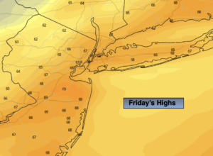
Friday:
Mostly sunny. A bit cooler. Highs in the upper 60s. West to Northwest winds at 5-10mph.
Tonight:
Partly cloudy. Much cooler. Lows in the lower 50s in the City, the 40s inland. North winds at 5-10mph.
Saturday:
Clouds, some sun. Cool. Highs in the lower 60s.
Sunday:
Mostly sunny. Highs in the lower 60s.
Monday:
Mostly cloudy with a chance of showers. Highs around 60º.
Tuesday:
Chance of rain. Highs in the upper 50s.