Synopsis:
A cool front will move through the area today. This will bring some relief from the oppressive conditions. At this time a few showers or storms are possible. It will not be a washout. Humidity levels will decrease later in the day.
By Sunday, true relief will arrive with readings just below the average high of the mid 80s and much lower humidity as Canadian high pressure get our applause. Sunday will by far be the better half of the weekend. Abundant sunshine is expected.
Stellar August conditions will continue into Monday. As the high moves off the Eastern seaboard a return flow of Southerly moist air will work in. This will result in more clouds Tuesday and Wednesday with the chance of spotty showers. Temperatures will be near the average high.
Keep it here for a no nonsense, no hype forecast.
Stay tuned.
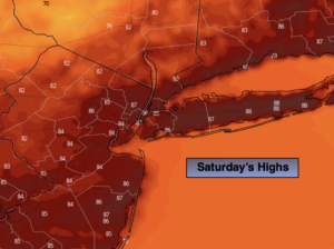
Saturday:
Hazy, very warm and humid. The humidity will drop some during the afternoon. Scattered showers or storms are possible. Most of the time the weather will cooperate. Highs in the upper 80s. Northwest winds at 5-10mph.
Tonight:
Becoming mostly clear, cooler and much less humid. Lows in the upper 60s in urban areas the upper 50s and 60s inland. Northwest winds at 5mph.
Sunday:
Sunny. Not as warm. Much less humid. Highs in the lower 80s.
Monday:
Mostly sunny. Low humidity. Highs in the lower 80s.
Tuesday:
Sun and clouds. Spotty shower possible. Highs in the lower to mid 80s.
Wednesday:
Sun and clouds. Spotty shower possible. Highs in the lower to mid 80s.