Synopsis:
Typical August conditions will be with us for the foreseeable future. The pattern will be more like what we experience in the dog days of Summer. High pressure will build along the East coast. Humidity levels will increase over the next couple of days.
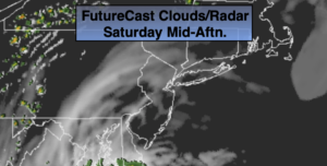
The only caveat (or minor hiccup) will be between this evening and Sunday morning. A weak low is forecast by some models to move up and off the coast. Scattered showers are possible during this timeframe. Both weekend days most of the time the weather will cooperate!
By late week hot temperatures are expected.
Keep it here for a no nonsense, no hype forecast.
Stay tuned.
Today:
Sun to clouds. Very warm. Highs in the mid to upper 80s. South to Southwest winds at 8-12mph.
Tonight:
Mostly cloudy with scattered showers. Lows in the lower 70s in urban areas, the 60s inland. Southwest less than 5mph.
Sunday:
Morning clouds and a possible shower to some sun. Highs in the lower to mid 80s.
Monday:
Partly sunny. More humid. Highs in the mid 80s.
Tuesday:
Mostly sunny. Very warm and humid. Highs in the upper 80s.
Wednesday:
Mostly sunny. Very warm and humid. Highs in the upper 80s to around 90º.