Synopsis:
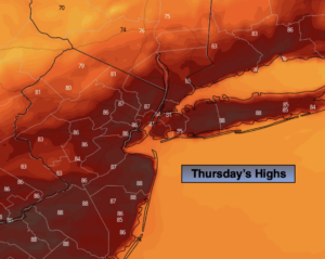
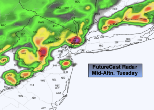
The heatwave has broke. A cool front will approach today with relief from the high heat. The humidity will still be noticeable. Scattered showers and storms are likely during the afternoon and evening as the front moves through. Some of the storms maybe strong and contain torrential downpours. A Flash Flood Watch is in effect through early tonight for Hunterdon, Somerset, Middlesex, Monmouth and Mercer counties.
On and off rain is likely overnight with the front slowly moving offshore.
Friday will be refreshing. Temperatures will finally be several degrees below the average high of 84º. Mostly cloudy skies are expected and a spotty shower can’t be ruled out.
Feel good temperatures will be with us for the 4 of July weekend. You won’t have to run for the AC. Saturday will not feel like July. Readings will only be within a few degrees of 70º! With an upper level low moving through spotty showers have been included in the forecast.
Sunday, July 4th will be the better half of the weekend. More sunshine and milder readings are expected.
Stay tuned.
Keep it here for a no nonsense, no hype forecast.
Today:
Sun and clouds, not as hot. Still humid. Scattered PM storms. Highs in the mid 80s. Winds becoming Northwest at 5-10mph.
Tonight:
Scattered showers and storms. Much cooler than recent nights. Lows in the 60s throughout. Northeast winds at 5mph.
Friday:
Mostly cloudy. A spot shower is possible. Highs in the mid to upper 70s.
Saturday:
Clouds, some sun. Spotty showers. Unseasonably cool. Highs in the lower 70s.
4th of July:
Mostly sunny. Highs in the upper 70s.
Monday:
Hazy, warm and humid. Highs in the mid 80s.